 Of the two alternatives being studied as part of the Bruckner-Sheridan project (besides the "no build" alternative), the only difference whether the Sheridan remains or is removed.
“We realize that we can’t just look at the highway facility itself; we need to look at the impact of a highway through the community it runs through, it needs to focus on not just moving traffic.” – NYSDOT Region 11 (NYC) Director Phil Eng on the Bruckner-Sheridan Interchange project, New York Times, July 12.
Few projects demand the type of broad vision described above as much as the Sheridan Expressway in the Bronx. For over a decade, community residents have asked state officials to ease the burden on the South Bronx by removing the 1.25-mile Sheridan and using the footprint for open space and development. But despite Director Eng’s words, last Tuesday’s NYSDOT stakeholder’s meeting on the Bruckner-Sheridan Expressway, the first in 2 years, was a live illustration of an organizational silo at work.
The meeting was convened for the presentation of the Department’s traffic “micro-simulation analysis” results, a process in which future traffic patterns and volumes are projected for each of the project’s alternatives. Besides a required “no build” alternative, NYSDOT is weighing two “build” alternatives, one which would remove the Sheridan (1E) and one which would keep it (2E). Aside from the fate of the Sheridan, the two are nearly identical, each creating a new interchange from the Bruckner to direct trucks to the Hunts Point food markets and industrial areas and a new alignment on the Bruckner Expressway to widen a bottleneck over the Bronx River.
Projected to year 2030, the Department sees skyrocketing traffic volumes under any scenario, generally projecting higher volumes on local roads if the Sheridan is removed. These latest results appear quite specific, but need to be taken with a whole shakerful of salt because they are based on the same traffic modeling process and underlying data which the Southern Bronx River Watershed Alliance concluded was “junk science” after hiring Smart Mobility, an impartial out-of-state consultant, to review the state’s data. That 2007 analysis found basic errors, faulty assumptions, and a fundamental mismatch between the project and the traffic model used to analyze it.
Both then and now, the project team used the NYMTC Best Practices Model, or BPM, for studying traffic patterns and projections. The Department used local traffic counts to calibrate the model, but the BPM’s design and underlying assumptions skew the latest results in the same way as the earlier numbers.
The BPM is a regional model, one which Smart Mobility called useful for analyzing “big picture land use and pricing assumptions.” However, “it is of more limited use in evaluating the different traffic impacts of the [Bruckner-Sheridan] Build alternatives, because the differences are small relative to the accuracy level of the model. Use of the BPM for screening the alternatives is appropriate, but… the modeling is too coarse to calculate significant differences in future traffic impacts between the alternatives.” Yet this is precisely what NYSDOT did and presented to the public.
Even if the BPM were an appropriate model to apply to the study area, garbage in still equals garbage out. Our report also found that “about half of the purported benefits [of keeping the Sheridan] result from model coding errors rather than any real transportation effects.” These included one-way streets mapped in the wrong direction and ramps coded with incorrect capacity numbers. The BPM also assumes that traffic steadily increases with population, unbounded by physical capacity constraints, producing “an implausibly high level of future traffic in the study area.” In fact, the magnitude of the projected traffic growth dwarfs the differences between the remaining alternatives.
Because of the model’s uncertain conclusions and the errors underlying the Department’s projections, the decision to remove or retain the Sheridan should be based more on the potential community benefits of each alternative — including, but not dominated by, traffic considerations. Unfortunately, study of the environmental, recreation, and economic benefits of a Sheridan removal is not part of NYSDOT’s plans.
» Continue reading…
One of the best opportunities for community members to speak in favor of the replacement of the Sheridan Expressway in the South Bronx with housing and open space is next week. NYSDOT will host its first “Stakeholders Committee” meeting in two years on July 13 at 6 pm at [...]
Note: Hanging out on the little-used Sheridan Expressway is only a small part of the job.
Want to join the movement to replace the Sheridan Expressway in the Bronx with mixed-use development, affordable housing, and park space? The Southern Bronx River Watershed Alliance — the coalition of Bronx and citywide groups [...]
Tonight, Tuesday November 10, the Southern Bronx River Watershed Alliance (SBRWA) is hosting a town hall meeting at The Point in Hunts Point on the competing plans for the future of the Sheridan Expressway. The public is invited to come and learn about the plans and give their input on this once-in-a-lifetime opportunity to [...]
Clockwise from top left: TSTC's Kyle Wiswall, The Point's Adam Liebowitz, Julien Terrell of Youth Ministries for Peace and Justice, SBRWA's Melanie Bin Jung, Nos Quedamos's Anna Vincente, and Joan Byron of the Pratt Center for Community Development.
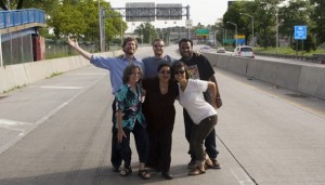
Members of the Southern Bronx River Watershed Alliance took to the Bronx’s Sheridan Expressway during [...]
Alexie Torres-Fleming (third from right) and members of Youth Ministries of Peace and Justice at the Sheridan Expressway.
Those of you who missed this week’s showing of PBS’s “Blueprint America: Road to the Future” can now view it at PBS’s website. The episode compares different modes of urban planning in Portland and Denver [...]
The Southern Bronx River Watershed Alliance‘s (SBRWA) efforts to convince NYSDOT to replace the Sheridan Expressway in the South Bronx with open space and mixed-use development will be featured in Wednesday’s episode of the PBS series “Blueprint America,” in an episode titled “Road to the Future.” According to PBS, “the documentary goes to three [...]
The Sheridan Expressway near Westchester Ave.
The Southern Bronx River Watershed Alliance has created an online petition as a piece of its campaign to open up 28 acres of land in the South Bronx for affordable housing, mixed-use retail and open space. The land is currently occupied by the redundant and lightly traveled [...]
Seattle's Alaskan Way Viaduct took the top spot in the Congress for the New Urbanism's "Freeways Without a Future" list.
Today the Congress for the New Urbanism, a national advocacy group, published a list of the top ten highway removal projects with the most potential to stimulate urban revitalization. Three projects TSTC has [...]
MTR readers may be surprised to learn that there are six serious proposals to remove urban highways in New York, New Jersey, and Connecticut.
Though the size, location, and economic situation of the host cities varies, all the projects aim to remove highways that bisect urban life and redevelop them into, well, cities, with things like housing, streets, parks, and offices.
The six projects are the Sheridan Expressway in the South Bronx, Route 5 in Buffalo, I-81 in Syracuse, Route 29 in Trenton, Route 34 in New Haven, and I-84 in Hartford. Right now, all but Route 5 in Buffalo (which is under litigation) are in the study phase. This situation begs the question: which project will win the “Race to Removal” gold medal? Below MTR offers an update on each project, along with speculation about who will win.
 A Pratt Center rendering of future development on the Sheridan footprint.
Swapping the Sheridan in the South Bronx
There is the long discussed plan to remove the Sheridan Expressway in the South Bronx and replace it with 28 acres of parks and housing. Advocacy by the Southern Bronx River Watershed Alliance, which includes Tri-State, Pratt Center, Sustainable South Bronx, Nos Quedamos, Youth Ministries for Peace and Justice and Mothers on the Move, successfully inserted the community plan into NYSDOT’s study of ways to increase access to Hunts Point market. The study is now reviewing four alternatives, two of these would remove the Sheridan.
Will it win the gold? It’s possible, but the silver is more likely. This project is on a good track, and NYSDOT Commissioner Astrid Glynn could use the Sheridan’s removal to step up her smart growth game, which so far has been rather passive. Recent design changes, strong community backing, and a blossoming interest in smart growth statewide also bode well for the teardown plan. The project is not moving rapidly however. It was first conceived in the mid-’90s (see MTR #s 124 and 181); the first step in the environmental review process was in 2003, the full environmental review did not start until last summer, and NYSDOT officials have said the study will not be complete until 2010. In other words, it may succeed, but it will take a few more years.
Battling in Buffalo
After years of study, the NYS DOT recently began the construction phase of a project to keep the berm-style elevated Route 5 roadway instead of replacing it with an at-grade boulevard that would increase access to Lake Erie. In response, Buffalo Niagara Riverkeeper, city council members, and recreation groups sued the agency in January, hoping to win modifications to the plan. The boulevard design, which would run from the Buffalo Skyway to Union Ship Canal, would open 77 acres for waterfront development and create the same number of jobs as the elevated alternative.
 A billboard in Buffalo evokes a famous Ronald Reagan quote to call for the transformation of Route 5 into a boulevard.
Bizarrely, the first phase of construction involves knocking down part of the roadway only to rebuild it again at a taller height. Equally frustrating, according to Riverkeeper executive director Julie Barrett O’Neil, is that NYSDOT was supportive of the boulevard design until the very last minute. The group also notes in a press release that an elevated Route 5 would work against efforts to eventually remove the nearby Skyway. In December 2006, Congress for the New Urbanism, Center for Neighborhood Technology, and Smart Mobility studied traffic patterns along the corridor and found that its low traffic volumes could easily be accommodated on a surface street. For more on this project, see this excellent video and Riverkeeper’s website.
Will it win the gold? The project may not win the gold medal, but the staff of Buffalo Niagara Riverkeeper should receive one for their hard work and advocacy. » Continue reading…
|
Masthead Mobilizing the Region is published by the staff of the Tri-State Transportation Campaign.
Editors
|