As MTR reported earlier this week, Tennessee became the sixth state to formally endorse the National Association of City Transportation Officials (NACTO) Urban Street Design Guide.
The NACTO Guide is considered “a blueprint for safe, multi-modal streets,” but 44 states (including New York, New Jersey and Connecticut) still rely on the American Association of State Highway and Transportation Officials’ (AASHTO) less progressive design guidelines for urban streets.
That got us thinking: What, if anything do the states that have endorsed the NACTO guide (California, Massachusetts, Minnesota, Tennessee, Utah and Washington) have in common?
Back in March of 2013, we used Walk Score to see if there was any correlation between a state transportation department’s priorities and where the people who staff those departments go to work each day.
Tri-State looked to see if — and to what extent — state departments of transportation lead by example. Specifically, how walkable are the locations of state department of transportation (DOT) headquarters, and what does this tell us about that state’s transportation priorities?
As it turns out, the state transportation departments that have endorsed NACTO’s Urban Street Design Guide are, for the most part, located in walkable, bikeable, transit accessible areas:
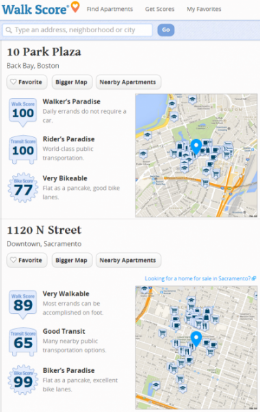
Massachusetts Department of Transportation
- Walk Score 100
- Bike Score 77
- Transit Score 100
Tennessee Department of Transportation
- Walk Score 92
- Bike Score 71
- Transit Score N/A
California Department of Transportation
- Walk Score 89
- Bike Score 99
- Transit Score 65
Washington Department of Transportation
- Walk Score 75
- Bike Score N/A
- Transit Score 47
Minnesota Department of Transportation
- Walk Score 69
- Bike Score 63
- Transit Score N/A
Utah is the outlier. Despite the move to endorse a more progressive design manual, the Beehive State’s Department of Transportation is located on a five-lane arterial southwest of Salt Lake City with a car-dependent WalkScore of 43 and a transit score of 37.
Where do DOTs in New York, New Jersey and Connecticut rank in comparison?
- New York State Department of Transportation in Colonie got a Walk Score of 58 and a transit score of 46
- ConnDOT’s Newington headquarters got a Walk Score of 57
- The David J. Goldberg Transportation Complex in Trenton, where NJDOT is located, scored the lowest in the region a Walk Score of 51.
*Bike Scores and Transit Scores are not available for all locations. Some Walk Scores have been adjusted since March 2013 — NYSDOT, ConnDOT and NJDOT Walk Scores were 72, 63 and 52, respectively.
[…] needs to revisit what type of “criteria” they are adhering to. An endorsement of the NACTO guidelines would give communities more […]
My first thought in reading this is to wonder about the usefulness of Walkscore. The NY and CT DOT buildings are located in completely different places from a pedestrian standpoint, although both in the suburbs. One is on a five lane arterial with full sidewalks, reasonably frequent crosswalks, street trees, lots of retail and services within walking distance, and is set fairly close to the street. The other is on a semi-freeway with no sidewalks or crosswalks, few if any services within walking distance, and is set back from the road with the door facing the parking lot in the rear. So one is easy to walk to and one if virtually impossible – yet they have the same score.
[…] Executive Director in April 2014. She has helped lead the creation of NACTO’s widely-heralded Urban Street Design Guide and Urban Bikeway Design Guide, oversaw the launch of NACTO’s […]