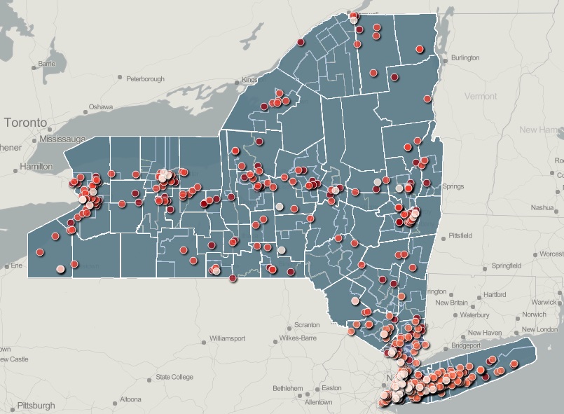
 Between 2010 and 2012, more than 900 pedestrians were killed on roads in New York State. To highlight how broad-based these fatalities are, Tri-State released an online map that shows the locations of New York* pedestrian fatalities with clickable layers that display boundaries for counties, congressional districts and state legislative districts. Viewers can turn these administrative boundary layers on and off to see fatalities that occurred within each layer. The map also includes New York City Council districts and municipal boundaries for Rockland and Westchester counties.
The release of the map coincides with calls from advocates and legislators for an additional $20 million in pedestrian and bicycle safety funding in the New York state budget, which is expected to be finalized before April 1.
With the information in these maps, elected officials can pinpoint the riskiest roadways for pedestrians in their districts and advocate more effectively for increased pedestrian safety infrastructure funding — like sidewalks, pedestrian countdown signals and enhanced crosswalks — in future state budgets and in the next federal transportation bill.
The map relies upon the most recent data available from the National Highway Traffic Safety Administration’s Fatality Analysis Reporting System (FARS) Encyclopedia as well as publicly available map files from the U.S. Census and county, state and city agencies.
*Maps are also available for Connecticut and New Jersey.
[…] From 2010 to 2012, there were more than 900 pedestrian fatalities in New York State. Map: TSTC […]