Earlier this week, Tri-State released an analysis on the region’s Most Dangerous Roads for Walking. This year, however, in addition to looking at total fatalities, we took a closer look at a few locations where pedestrian deaths were clustered.
Why do this? The intention of Tri-State’s Most Dangerous Roads analysis is to encourage state and local governments to make safety improvements to roads where multiple pedestrian fatalities occur. By targeting specific areas on those roads where fatalities are clustered, an even stronger case can be made for critical changes like better pedestrian crossings, traffic calming measures and enhanced speed enforcement strategies, while also advocating for infrastructure overhauls along entire corridors. Here are a few fatality clusters that stood out:
Broadway, Manhattan, NY Nine pedestrians died on Broadway in Manhattan between 2010 and 2012. Broadway is over 13 miles long, but seven of the nine fatalities occurred on the 4.7-mile stretch of upper Broadway between 99th Street and 192nd Street. During the Bloomberg administration, the New York City Department of Transportation put considerable focus into making southern Broadway safer for pedestrians. Fortunately, change is afoot farther uptown, too: NYC DOT recently announced a plan to redesign the intersection of Broadway and 96th Street, and last November, Community Board 12 endorsed a plan to shorten crossings at Broadway and Dyckman Street in Inwood.
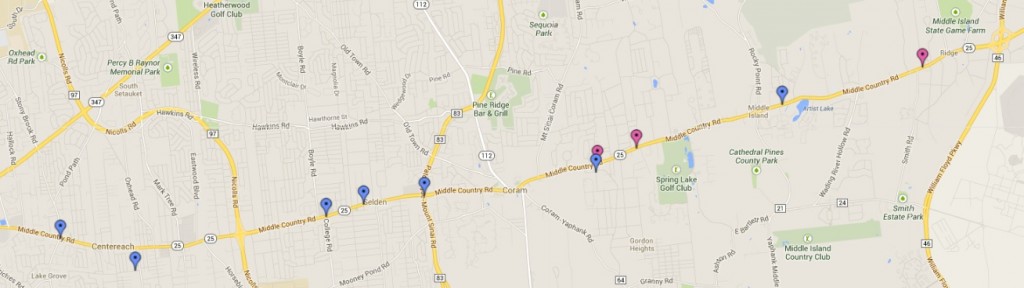
Route 25 (Jericho Turnpike/Middle Country Road), Suffolk County, NY With 16 pedestrian fatalities from 2010 through 2012, Route 25 is Suffolk County’s most dangerous road for walking, and the region’s most deadly road as well. Half of the pedestrian fatalities that occurred along Route 25 in Suffolk County were on the 11.5-mile stretch from Centereach to Ridge. In 2012, the New York State Department of Transportation made some improvements to Route 25 in Nassau County; the state should continue safety improvements into Suffolk County as well.
US-130 Burlington County, NJ With 12 pedestrian fatalities from 2010 to 2012, Burlington County’s US-130 was the county’s most deadly road for pedestrians, and the most dangerous road for pedestrians in the entire state. Within Burlington County, eight pedestrians were killed on the approximately 7.5 miles from Cinnaminson to Willingboro. With initiatives such as Operation 130 Safe Passage, state agency leaders and elected officials have taken action to make US-130 safer for pedestrians. However, pedestrian infrastructure, such as continuous sidewalks, median islands and crosswalks, must be added to this entire stretch.
Fairfield County, Bridgeport, Hartford and Waterbury, CT With 11 fatalities in three years, US-1 is Connecticut’s most dangerous road for walking. Last year, the Connecticut Department of Transportation expedited pedestrian improvements on US-1 in Westport. The agency is also seeking to add sidewalks to US-1 in Stratford, but more comprehensive improvements are needed. Six of the 11 fatalities occurred along US-1, were in Fairfield County. In addition, in the three years from 2010 through 2012, Bridgeport (six fatalities), Hartford (six fatalities) and Waterbury (nine fatalities) accounted for nearly 20 percent of all pedestrians killed in Connecticut.
These aren’t the only locations where fatalities are clustered; see if you can find others.
[…] Targeting Locations Where Pedestrian Deaths Are Clustered […]