Last week in a room packed with community leaders and organizations, residents, elected officials and their staff, the NYC Departments of Transportation and City Planning presented preliminary scenarios leading up to final recommendations from its nearly two year long Sheridan-Hunts Point Land Use Study. The federally-funded (TIGER II), multi-agency study is analyzing how modifications to the Sheridan Expressway and South Bronx roadway network will impact neighbors in the surrounding area. A final recommendation on land use and transportation within the Sheridan Expressway footprint is expected this June.
Ten months after the unfortunate decision to eliminate a Sheridan-removal option from the study scope which was a key component of the community’s vision plan for improved health, economic development, and improved access to the Bronx River, the presentation offered a preliminary glimpse of the traffic impacts and land use potential being examined. Central to the recommendations are traffic analyses of the remaining scenarios: Retain, Modify Separated, or Modify Combined. And what was shown was that traffic on most local roads would be reduced without a discernible impact on overall travel times into and out of Hunts Point. For examples:
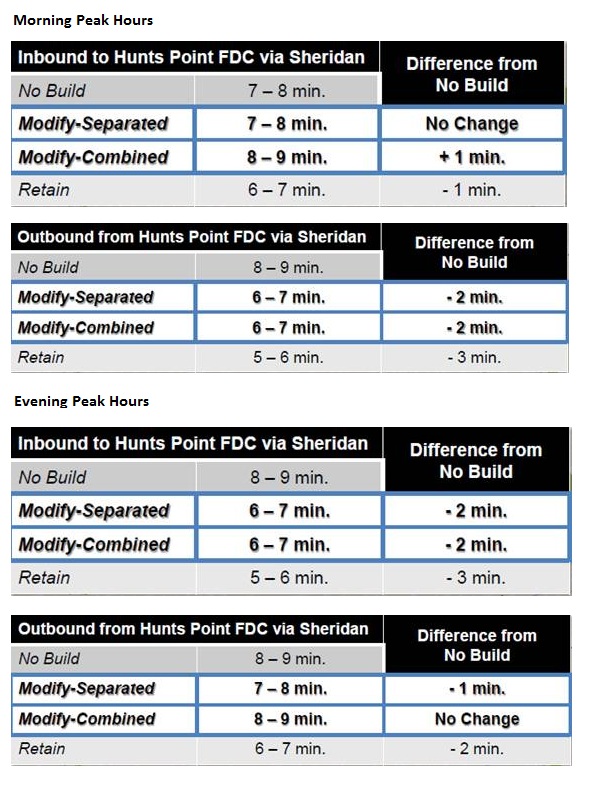
Each scenario includes the installation of ramps from the Bruckner Expressway directly to the Hunts Point peninsula for traffic coming and going east on the elevated Bruckner Expressway as well as other changes outside the Sheridan footprint. Here is a break-down of the three scenarios:
|
Retain |
Modify Separated |
Modify Combined |
|
|
|
The presentation was a mixed bag: some positive elements were presented while other key studies were not completed and pivotal information not shared. The positive elements of the analysis included:
- A focus towards reducing truck traffic on local streets and through residential neighborhoods
- Improved pedestrian safety around heavily used transit stations and intersections
- Closure of the entrance ramp onto the Sheridan Expressway at Hunts Point Avenue, an intersection with yearly pedestrian fatalities
- Improved pedestrian access to the Bronx River and Greenway
- Some traffic calming measures and encouragement of mixed use zoning
Unfortunately, there were significant omissions from the study including:
- Modeling the impact of closing the northbound Sheridan off-ramp at Westchester Avenue which could further improve pedestrian safety and comfort on local streets
- Modeling the traffic impacts of ramps connecting the Bruckner Expressway and Hunts Point to and from the west; an improvement that would further enhance direct commercial access to Hunts Point while reducing that traffic on local streets
- Emissions and environmental impacts of shifting traffic patterns and increased truck traffic on certain roadways were not shared
- Study data from the other four city agencies
Overall, there is a focus on keeping truck traffic off local streets, improving pedestrian safety, providing connections to the riverfront, encouraging mixed-use development, and enhancing the vibrancy of the community. These changes would be a large step in the right direction for the South Bronx, but modeling and possibly recommending closing the northbound Sheridan off-ramp at Westchester Avenue and additional ramps connecting the Bruckner Expressway and Hunts Point are a few examples of what more can and should be done.
[…] Sheridan Expressway TIGER II Study Moves Toward June Completion Date (MTR) […]
[…] traffic analysis left the Tri-State Transportation Campaign’s Vincent Pellecchia optimistic, writing that “traffic on most local roads would be reduced without a discernible impact on overall travel […]
Where are the results of the base-year AM and PM model(s) calibration ? That model calibration report should be published on the Study’s www site. In summary, the future modeling results shown in the presentation are basically no different from the results produced from the NYSDOT’s EIS. This NYCDCP/NYCDOT study was basically a waste of #1,000,000. What was the point of replicating the modeling – the heart of the technical analysis !
Good work, keep it up.